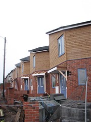
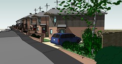
Here’s the latest image from our project in Stourbridge. This shot shows the way each of the properties has a slightly different relationship with the street, depending on the paving and the door position.
Construction should be completed soon. We’ve also submitted the project for a Building For Life award – we hope to get a gold standard result…
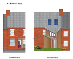
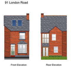
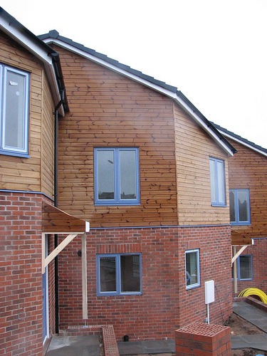
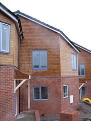
For the last few months we’ve been working on a project to refurbish 6 terrace properties in Newcastle-Under-Lyme. We won the project after a competitive bid last summer and last week saw the launch of the public web site charting the progress of the work. We’ll be recording the project on the eocterrace web site using a number of blogging techniques such as a written diary, a phonecam blog, flickr images and del.icio.us links.
http://ecoterrace.co.uk
The goal is to substantially increase the environmental performance of the properties and help take part in the progress of the national debate about the importance of improving the quality of the country’s existing housing stock.
One of the most interesting aspects of the project will be the post-occupancy monitoring work we will be completing in collaboration with the guys from Hockerton Housing Projects. In a couple of years time we will hopefully have something valuable to say about the actual results of some of the design techniques and products, as well as an understanding of what it’s like to live in a property like this.
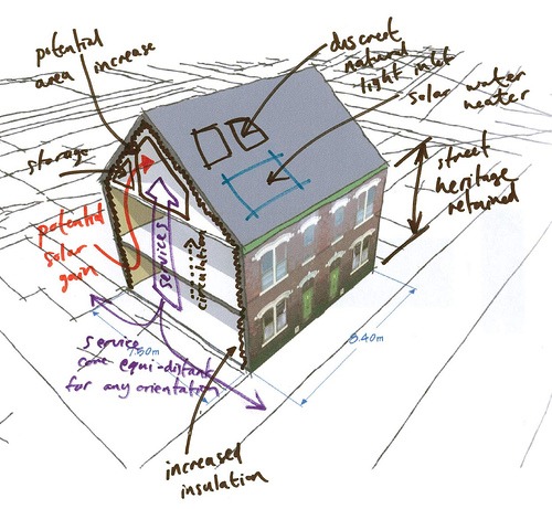
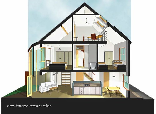
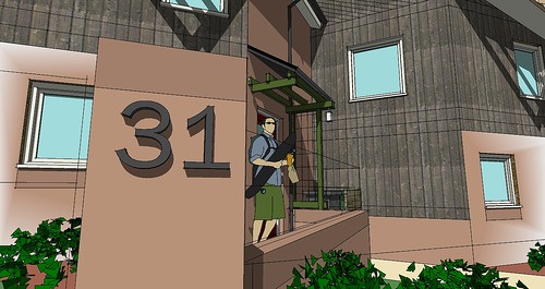
Architecture Week 2007 is a good time to announce one of our latest commissions to develop an environmentally sound refurbishment proposal for terrace properties in Stoke-on-Trent. Continuing our explorations into solar passive architecture, the design delivers robust, replicable solutions to both the improvement of the fabric, the quality of the living space and the thermal performance.
Here’s a copy of our winning presentation and a fly-by model of the exterior showing the 2 storey spaces proposed as replacements to the standard usually outrigger found on Victorian terrace housing. The submission was completed in collaboration with Staffordshire Housing Association and Brown & Clowes for Renew North Staffordshire and Newcastle-Under-Lyme Borough Council.
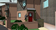
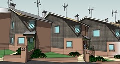
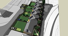
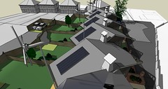
One of our latest projects has just been granted planning approval by Dudley Metropolitan Borough Council. The design responds to tight site constraints and a brief calling for an exemplar, environmentally friendly scheme.
Carefully orientated to make the most of the south-east and south-west sun, the saw-tooth layout and innovative roof plan create an animated, interesting street scene.
* the images shown are taken from the initial 3D modelling work – the wind turbines shown were subsequently removed due to concern about cost and their likely poor performance in an urban area
A full copy of the design and access statement is available as a PDF: Saw-tooth housing
Street elevations are also available: Street elevations 1
Click on the following image to see ‘fly-by’ animation:
This project was developed in collaboration with Kier Homes and Black Country Housing Association.
Notes from a recent trip to the Ecobuild conference:
It goes like this: DETR figures state that for a neighbourhood to be served by a viable transport network you need 5000 dwellings. To design a ‘walkable’ neighbourhood we should provide all key facilities within a 10 minute walk. This defines an area contained within a circle of 600m radius. Take away the space recognised as necessary for communal facilities and roads and you’re left with a dwelling density of 50 per hectare.
Cue a series of images showing potential layouts at 50 per hectare, which MacCormac admitted himself was barely the beginning of any qualitative judgement of the resulting spaces. His key point, touched on throughout the presentation, was how this qualitative judgement is dependent on an improved understanding of the net vs. gross density – or, crudely put, the houses vs. the spaces.
He’s absolutely right and there’s a thread across this entry that moves from the CABE audit I mentioned earlier (which has much to say about better highways integration), to the car free environment of Trystan Edward’s terraces (whose high density probably land back at about 50 when you introduced parking), through the Span story of quality landscape better mediating the Radburn car/pedestrian divorce, to the shifting tessellations of MacCormac’s houses and gardens.
Full notes on all the speakers can be found on Rob’s weblog: no2self.net
We’re delighted to report that our entry for the Euroclad competition has been awarded a commendation. This was the last collaboration between Tony and Rob before Tony’s untimely death, so it seems particularly fitting that it might achieve an award.
Rob will be in London attending the awards ceremony on October 19th.
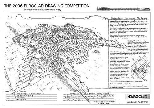
Here’s our entry to the Euroclad drawing competition, which asked entrants to ‘sketch a fresh look for Brighton’s West Pier’.
Chambers for a Brighton Memory Palace
Concept:“The first pier at Brighton was known as The Chain Pier, and there was a silhouettist working on it throughout most of it’s history. The slhouettists moved to the West Pier when it opened in 1866, and continued more or less continuously until shortly before it’s closure in the 1970’s.”1
The profile of a sea front pier is a well understood, easily recognisable form that stirs recollections. The history of the silhouette cutters on West Pier is captured within the full scale profile and becomes a surface to incite and then receive the memories of the people of Brighton.
Repeated, rotated and woven together to form a field of chambers housing exhibitions, events and installations; the grid becomes a set of co-ordinates that control the curating of time and topics.
Construction: The spaces are created by intersecting, perforated metal clad walls with an opening in each side connecting to the adjacent chamber. Exposed spaces drain towards the edges and covered areas shed rainwater into the cavity between the walls. Colour controlled lighting in the cavity seeps through the perforations and assists themed curation of exhibitions by directing visitors across the grid. Lightweight tent structures stretch over the volumes that trace a wandering path across the grid providing alternative environments for different events/objects.
Curate: The grid of silhouettes conveys the passing of time in one direction and cultural topic in the other. The profiles heading away from the beach out onto the sea carry the topic through the intersecting date lines parallel with the shore. We begin at the shore in 18652 and travel towards the horizon to the present day, crossing decades as we move from chamber to chamber. As time passes the structure continues to grow into the sea and new topics are added along the beach. Non-linear journeys through history are suggested within the volumes traced across the grid by the silhouettes of the original pier buildings.
The co-ordinates provide public meeting places with a nostalgic subtext.
The partners here at Axis Design have a long history of teaching (working here is always an education!) and at the office we have copies of lecture notes and books that are all worthy of re-publishing via the web.
Under a new category simply entitled ‘notes’ we will be posting urban design lecture notes to share with visitors. These are made available under a Creative Commons license.
For the first installment there are three PDF files on offer: 1, 2 and 3.
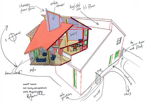
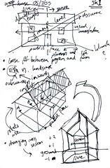
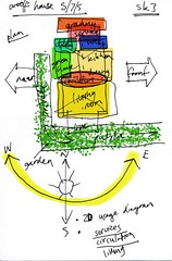
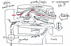
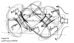
Part of the goal of Open Practice day this Friday is to talk about how architects work. One of the projects available for viewing on Friday will be some recent design work for a single domestic residence on a challenging suburban site.
The challenges of difficult access, overlooking from nearby houses and substantial level changes were developed into opportunities through a series of sketches and diagrams. The diagram is an important device in architecture and the hand drawn sketch continues (in an industry ruled mostly by computer aided design) to be the best way to explore them.
Come and visit on Friday and we can talk about the way the design developed…