British Homes Awards – Gran Designs

The quality of supported housing for the 55+ market in the UK is a topic we’ve been discussing here at Axis Design a lot over the last few years. This year’s brief for the British Homes Awards gave us the opportunity to explore some of our ideas and show how we believe the industry could turn to existing housing solutions from the holiday home sector combined with improved landscape and infrastructure to meet the aspirations of retiring baby boomers.

Here’s our response to the Lifetime Homes challenge set by the British Homes Awards 2009 (click images for full size):
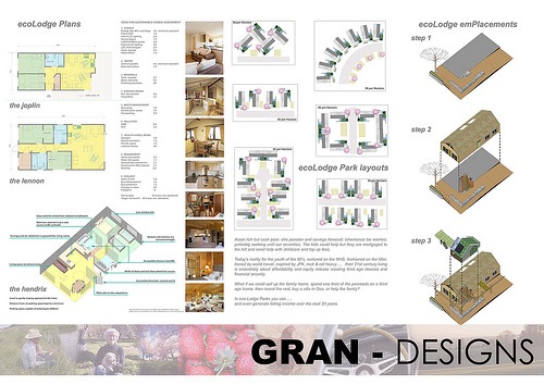
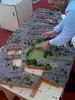
Eco Lodge Parks 

Asset rich but cash poor; dire pension and savings forecast; inheritance tax worries; probably working until our seventies. The kids could help but they are mortgaged to the hilt and need help with childcare and top up fees.

Today’s reality for the youth of the 60’s, nurtured on the NHS, fashioned on the Mini, honed by world travel, inspired by JFK, rock & roll heavy….   their 21st century living is essentially about affordability and equity release creating third age choices and financial security.

What if we could sell up the family home, spend one third of the proceeds on a third age home, then invest the rest, buy a villa in Goa, or help the family?

In eco-Lodge Parks you can….. and even generate letting income over the next 20 years.

British Homes award entry

British Homes Awards entry

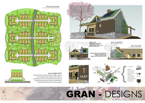
Thanks to Jez Sanders from Red Landscape for collaborating with us on this work. Although we didn’t make the shortlist we’re still very pleased with the concept and hope to get the opportunity to develop it in the future.

(see the full entry for further text)

Continue reading “British Homes Awards – Gran Designs”

YouCanPlan Lozells

After months of intensive collaboration with software developers Slider Studio, we can now announce the launch of our latest development in community consultation innovation. On behalf of Birmingham City Council and Urban Living we’ve created a 3D software platform for the Lozells neighbourhood that allows residents to see the latest proposals for the area by the city’s urban design team; then send feedback and chat with other residents and project team members.

slide5.JPG

The options can be viewed from above or from street level with the ability to switch between proposals from any point, helping the viewer make comparisons. It can be used both as an offline tool at venues without an internet connection and also online from home, outside of the usual time/location constraints for consultation events. The online option allows us to update the proposals as the project progresses and demonstrate the impact of the feedback we receive. Hopefully this project will provide a platform that Birmingham City Council can continue to deploy in future projects, commissioning 3D information to use in the software and for the creation of rapid protoyped models to use at public events.

YouCanPlan software YouCanPlan jigsaw YouCanPlan model base YouCanPlan model building

Visit the project web site and download the software at: http://vision-lozells.org

 *UPDATE: You can also see video footage of the software being used for the first time at a recent event by visiting the Lozells News web site. *

be2camp

networkbe2camp.jpg
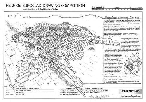
We recently took part in the be2camp ‘unconference’ in London. The aim of the day was to discuss and share ideas about how ‘web 2.0’ or social media tools on the internet can be used by the built environment.

Along with Micheal Kohn from Slider Studio we presented our first images on the development work we’re doing to create a virtual consultation tool that will allow residents to see the proposals for their neighbourhood in 3D. Users of the software will be able to walk around a model of their streets, see options and comment on the ideas.

The be2camp  event was a huge success and we’re looking forward to developing a similar forum in the Midlands.

A video presentation and a copy of the slides are available on the be2camp web page.

Birmingham Climate Change Festival

If you’d like to talk to us about our work and find out more about projects such as Queens Road or ecoterrace.co.uk, please come and visit us at the Climate Change Festival next week. We’ll be taking part in ‘Green Technology Day’ on Wednesday 4th June.

climate change

*Update:*

The event was a great success and we thoroughly enjoyed talking to everyone who visited the event. Here’s the video we prepared to show on the screens placed around the city’s square:

Think08 conference

Axis Design Director, Rob Annable, will be attending Think 08 next week and taking part in the session at 4:30pm on the 7th, thanks to an invite to present from Phil Clark.

Here’s the summary of the session:

Embracing the existing estate and communities

What’s already built is a much greater part of our built environment than new development. How do we tackle the existing estate to deliver greater sustainability in social, economic and environmental terms? A panel will discuss the issues generated and solutions required by outdated workplaces, ageing housing stock and the sustainability problems they cause. This will include a consideration or legislative hurdles in tackling the built stock as well as a live example of green refurbishment work being carried out on Victorian properties in Newcastle-Under-Lyme.

Chair: Denise Chevin, Editor, Building
Kate Symons, Associate Director, Building Research Establishment
David Strong, Chief Executive, Inbuilt Consulting,
Rob Annable, Director, Axis Design Architects
Dr Douglas Robertson, Head of Applied Social Sciences, Stirling University
and Joseph Rowntree Foundation
Roger Hawkins, Director, Hawkins Brown

And here’s the PDF of the full program: Think08 program

Ecobuild 2007

Notes from a recent trip to the Ecobuild conference:

It goes like this: DETR figures state that for a neighbourhood to be served by a viable transport network you need 5000 dwellings. To design a ‘walkable’ neighbourhood we should provide all key facilities within a 10 minute walk. This defines an area contained within a circle of 600m radius. Take away the space recognised as necessary for communal facilities and roads and you’re left with a dwelling density of 50 per hectare.

Cue a series of images showing potential layouts at 50 per hectare, which MacCormac admitted himself was barely the beginning of any qualitative judgement of the resulting spaces. His key point, touched on throughout the presentation, was how this qualitative judgement is dependent on an improved understanding of the net vs. gross density – or, crudely put, the houses vs. the spaces.

He’s absolutely right and there’s a thread across this entry that moves from the CABE audit I mentioned earlier (which has much to say about better highways integration), to the car free environment of Trystan Edward’s terraces (whose high density probably land back at about 50 when you introduced parking), through the Span story of quality landscape better mediating the Radburn car/pedestrian divorce, to the shifting tessellations of MacCormac’s houses and gardens.

Full notes on all the speakers can be found on Rob’s weblog: no2self.net

Euroclad competition

Here’s our entry to the Euroclad drawing competition, which asked entrants to ‘sketch a fresh look for Brighton’s West Pier’.


Chambers for a Brighton Memory Palace

Brighton-Memory-Palace

Concept: “The first pier at Brighton was known as The Chain Pier, and there was a silhouettist working on it throughout most of it’s history. The slhouettists moved to the West Pier when it opened in 1866, and continued more or less continuously until shortly before it’s closure in the 1970’s.”1

The profile of a sea front pier is a well understood, easily recognisable form that stirs recollections. The history of the silhouette cutters on West Pier is captured within the full scale profile and becomes a surface to incite and then receive the memories of the people of Brighton.

Repeated, rotated and woven together to form a field of chambers housing exhibitions, events and installations; the grid becomes a set of co-ordinates that control the curating of time and topics.

Construction: The spaces are created by intersecting, perforated metal clad walls with an opening in each side connecting to the adjacent chamber. Exposed spaces drain towards the edges and covered areas shed rainwater into the cavity between the walls. Colour controlled lighting in the cavity seeps through the perforations and assists themed curation of exhibitions by directing visitors across the grid. Lightweight tent structures stretch over the volumes that trace a wandering path across the grid providing alternative environments for different events/objects.

Curate: The grid of silhouettes conveys the passing of time in one direction and cultural topic in the other. The profiles heading away from the beach out onto the sea carry the topic through the intersecting date lines parallel with the shore. We begin at the shore in 18652 and travel towards the horizon to the present day, crossing decades as we move from chamber to chamber. As time passes the structure continues to grow into the sea and new topics are added along the beach. Non-linear journeys through history are suggested within the volumes traced across the grid by the silhouettes of the original pier buildings.

The co-ordinates provide public meeting places with a nostalgic subtext.

“Should we meet at 1964/Mods or 1975/Pier ?”


With apologies to Charles Moore and Donlyn Lyndon for the Chambers for a Memory Palace rip off. The drawing is also available as a PDF.

notes:
1. from ‘The Silhouette Tradition of Brighton Pier’ by Edo Barn.
2. the year the West Pier was constructed

Making Urban Places

The partners here at Axis Design have a long history of teaching (working here is always an education!) and at the office we have copies of lecture notes and books that are all worthy of re-publishing via the web.

Under a new category simply entitled ‘notes’ we will be posting urban design lecture notes to share with visitors. These are made available under a Creative Commons license.

For the first installment there are three PDF files on offer: 1, 2 and 3.

Continue reading “Making Urban Places”

Diagrams

Part of the goal of Open Practice day this Friday is to talk about how architects work. One of the projects available for viewing on Friday will be some recent design work for a single domestic residence on a challenging suburban site.

The challenges of difficult access, overlooking from nearby houses and substantial level changes were developed into opportunities through a series of sketches and diagrams. The diagram is an important device in architecture and the hand drawn sketch continues (in an industry ruled mostly by computer aided design) to be the best way to explore them.

Come and visit on Friday and we can talk about the way the design developed…

sk1sk3

sk7_v2lay_02

cutaway